- India
- International
Friday, Apr 19, 2024
Journalism of Courage
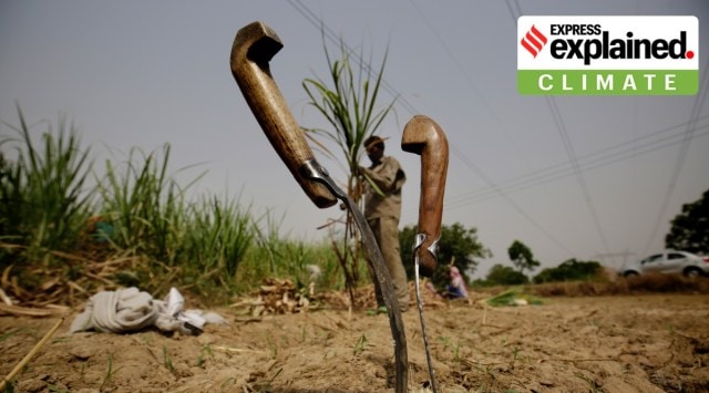 Farmers in Uttar Pradesh and Jharkhand are still awaiting a good spell of rainfall to take up sowing. (Express Photo: Praveen Khanna, Representational)
As the southwest monsoon season completes three quarters of its four-month June-September duration, Uttar Pradesh and Jharkhand are seeing their worst rainy season in 122 years. As farmers in the middle Gangetic basin continue to wait for a spell of good rain to begin sowing, district administrations are working on contingency plans for the fallout of a possible drought. These major rice-producing states could be hit by a serious scarcity of food and water, with potential to affect India’s kharif production for the year.
The southwest monsoon of 2022 in Jharkhand and Uttar Pradesh has so far been the worst since records of rainfall began to be kept in 1901.
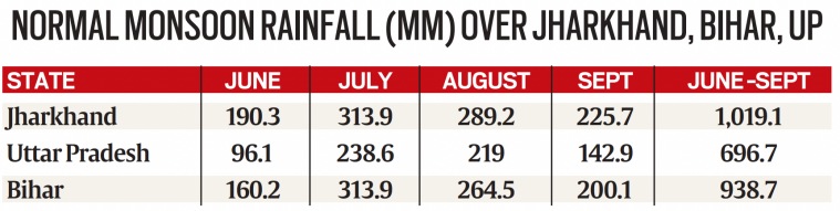
JHARKHAND: Between June 1 and August 14, Jharkhand received 395.8 mm of rain, 39 per cent in deficit of the normal 650.2 mm for this period. Only twice before has rainfall in Jharkhand during the period June 1-August 31 fallen below 500 mm — in 2010 (439 mm) and 1993 (469.6mm), according to data from the India Meteorological Department (IMD). A smaller deficit of 593 mm was recorded in 2019.
Two districts — Chatra and Jamtara — have not received normal rainfall during even one of the past 10 monsoon weeks, the IMD’s week-wise rainfall data until August 10 show. All other districts barring East Singhbhum have received normal rainfall for no more than three weeks during this period.
The driest districts of Jharkhand during this period overall have been Pakur, with a deficit of 72 per cent; Sahebganj (- 70 per cent), Jamtara (- 69 per cent), Giridih (- 66 per cent), Chatra (- 60 per cent), Deoghar (- 56 per cent), Garwah (- 57 per cent), Dumka (- 52 per cent) and Palamu (- 51 per cent).

As per the August 11 reservoir storage report by the Central Water Commission (CWC), reserves in the six major reservoirs in the state were 0.594 billion cubic metres (BCM), half the 10-year average of 1.18 BCM, and only 30 per cent of the total storage capacity or full reservoir level (FRL). The reservoirs were at 78 per cent of FRL at this time last year.
UTTAR PRADESH: In Uttar Pradesh, 263 mm rain was recorded up to August 14, a deficit of 44 per cent from the seasonal average of 470.1 mm during this period. UP has been the most rain-deficient state in the country since the beginning of the season. Between 1901 and 2021, UP’s driest monsoons during the months of June to August were witnessed in 1987 (349.3 mm), 2009 (365 mm), 1996 (392 mm), 2014 (394.3 mm) and 1972 (424.3 mm), according to IMD data.
The worst affected districts in UP until August 14 were Farrukhabad (- 79 per cent), Jaunpur, Ghaziabad and Gautam Budh Nagar (- 72 per cent each), Kanpur Dehat and Kushinagar (- 71 per cent each), Rampur (- 70 per cent), Mau (- 66 per cent), Baghpat (- 65 per cent), Jyotiba Phule Nagar and Chandauli (- 64 per cent each), Gonda and Bahraich (- 63 per cent each), Ballia (- 62 per cent), Kaushambi (- 61 per cent), Basti (- 60 per cent), Amethi (- 58 per cent), and Ayodhya (-53 per cent).
In eight major reservoirs in the state, storage was at 28 per cent of total capacity, according to the August 11 bulletin of the CWC. This figure was 53 per cent at this time last year. The current water reserves in these dams is 2.15 BCM against the 10-year average of 3.09 BCM.
BIHAR: In Bihar, where floods in the Ganga and its tributaries are the monsoon norm, this year has been anything but normal. Until August 14, the state had recorded 385.7 mm of rain, 39 per cent in deficit of the normal of 628.1 mm for this same period.
For Bihar, the 2022 monsoon could turn out to be the worst in 50 years. Only once before in the past half century has the state received less than 400 mm of rain during the period June 1 to August 31 — 375 mm in 1972. Other poor monsoon years for these three months were 2010 (466.6 mm), 2013 (503.2), 2012 (573.9 mm), and 1992 (588.7 mm).
Overall, July over East and Northeast India ended with a rain deficit of 45 per cent — the driest July for these regions since 1903. Since the onset of the 2022 monsoon, Manipur, Tripura, and West Bengal have been in the rainfall ‘deficient’ category, with deficits of 40 per cent, 28 per cent, and 21 per cent respectively. Assam (positive deviation of 4 per cent), Meghalaya (3 per cent), and Sikkim (11 per cent) have recorded ‘normal’ rainfall. Arunachal Pradesh has seen a negative deviation of 12 per cent, but that is still in the ‘normal’ band.
JHARKHAND: July and August are the rainiest months in the state, and account for 31 per cent and 28 per cent respectively of the season’s total rainfall. Jharkhand receives 84 per cent of its annual rainfall in the monsoon months of June to September.
Over recent decades, rainfall in Jharkhand has been trending lower than the annual average of 1,211.4 mm, according to the IMD’s Rainfall Variability over Jharkhand (1989-2018) report. Rainfall in June has been decreasing over the districts of Garhwa, Chatra, and Koderma; for September, a decreasing trend has been observed over Chatra, Koderma, Godda, Sahebganj and Dhanbad. No trends are visible for rainfall in July and August.
Also, no district has shown an increase in rainfall during the monsoon season, the report says. The largest number of rainy days between June and September has varied between 46 and 50. The districts of Gumla, Simdega, West Singhbhum, East Singhbhum, Dhanbad, Jamtara, and Pakur typically see the most rainy days in the state.
UTTAR PRADESH: Thirty-four per cent of the state’s monsoon seasonal rainfall occurs in July and 31 per cent in August. UP gets 89 per cent of its annual rainfall during June to September.
IMD reports have noted a decline in both the southwest monsoon rainfall and total rainfall over UP, according to the IMD’s Rainfall Variability over Uttar Pradesh (1989-2018) report. An insignificant increasing trend has been observed in rainfall during June, July, and August, while rainfall during September has been declining significantly.
Gorakhpur district receives the highest rainfall in UP during the southwest monsoon season. Overall, districts in the northeast of the state, except Kushinagar and Ballia, receive more rain compared to districts in the southwest. Between 421 and 560 mm of rain is commonly received during the southwest monsoon season by the districts of Baghpat, Bulandshahr, Aligarh, Mathura, Mahamaya Nagar, Etah, Ayodhya, Agra, Etawah, Kannauj, Auraiya, Kanpur Dehat, Kanpur, Mahoba, Rae Bareli, Kaushambi and Kushinagar.
BIHAR: The state receives 33 per cent of its monsoon rainfall in July and 28 per cent in August. More than 85 per cent of the annual rainfall is realised between June and September.
According to the IMD’s Rainfall Variability over Bihar (1989-2018) report, rainfall during the June-September period has been showing a decreasing trend.
Among the districts, Kishanganj, Araria, Purnia, and West Champaran receive the highest rainfall during the southwest monsoon season. The monsoon seasonal and annual rainfall over districts in the southwest is generally lesser than in the rest of the state.
 Source: IMD
This monsoon season has seen the development of only three low pressure systems over the Bay of Bengal, mostly off the coast of Odisha. None of these systems had an impact over Jharkhand, UP, or Bihar. “The low pressure systems did not move along Bihar, Jharkhand, and Uttar Pradesh,” Pulak Guhathakurta, head of the Climate Research Division at IMD, Pune, said. These unfavourable conditions contributed to the high rainfall deficits throughout the season, he said.
In addition, the east-west low pressure monsoon trough — the second major reason for rainfall — has remained to the south of its normal position for most days in July and August so far. The location of the monsoon trough, its oscillation and duration over a specific location, directly affect rainfall activity over regions to the south of the trough.
Thus, when the monsoon trough is located to the south of its normal position, there is active or vigorous rainfall over most parts of central and peninsular India. And when it shifts to the north of its normal position, or lies along the Himalayan foothills, Uttar Pradesh, Bihar, Jharkhand, West Bengal and the Northeastern states benefit.
For UP, the IMD’s Agriculture Meteorology (Agrimet) Division has suggested that transplantation of rice should be carried out until August 15, and that short-duration varieties should be sown. Experts have also advised farmers to cultivate red gram. “We recommend that farmers should opt for inter-cropping, and take up short-duration rice varieties,” Kripan Ghosh, head of the division said.
For farmers in Jharkhand, the division has suggested adopting measures to conserve moisture in the soil. No sowing is advised until there is 50 mm to 60 mm of rainfall and sufficient moisture for at least three consecutive days. Short-duration rice, millet, maize, and arhar should be considered for the rest of the season, it has said.

Can UP interfaith live-in couples get police protection?Subscriber Only

Heart disease & maternal deaths: New ICMR study attempts toSubscriber Only

UPSC Key | FDI in space sector, heavy rainfall inSubscriber Only
S Y Quraishi on life after poll bonds: The nextSubscriber Only

The strategic importance of Andaman & Nicobar IslandsSubscriber Only

AAP Bharuch candidate's frontline fighters are his two wivesSubscriber Only
Is there hope for India’s dying wastelands?Subscriber Only

In Delhi refugee camp, a Nehru from Pak awaits citizenshipSubscriber Only
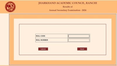
Jharkhand Academic Council (JAC) will declare the Class 10 results today (April 19) on their official websites. Students can access their scorecards by entering their login details on jac.nic.in, jharresults.nic.in, or jac.jharkhand.gov.in. The marksheet will include personal details, subject-wise marks, and a cumulative score. Last year, the pass percentage was 95.38%.